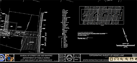
Click below to review the Topographic Survey of Ridge Lane completed by the Bureau of Street Use and Mapping: 2013-99_RIDGE LANE TOPOGRAPHIC SURVEY SHEETS 1 and 2 This survey shows property lines and topography for the entire run of Ridge Lane.
Category Archives: Documents
SAFE Report on Ridge Lane
On Dec 12, 2013 Furlishous Wyatt, Jr. from SF SAFE (Safety Awareness For Everyone) led members of RLN on a walk down Ridge Lane to do a safety survey. Attached is his report which includes many observations & recommendations about how we can make our neighborhood safer. Click here for PDF Document: CPTED Ridge Lane PedestrianContinueContinue reading “SAFE Report on Ridge Lane”
RLN Flyer Template
Click below to get a Word Doc that you can use to create flyers to publicize our group: RLN Flyer Word
Survey Cost Estimate
This document breaks down the cost for surveying Ridge Lane section by section. We’ll discuss it at the December 12th meeting. Fee for San Jose Ave. to Caine Ave. $13,000 Fee for Caine Ave. to Tara St./Majestic St. $11,000 Fee for Tara St./Majestic to Louisburg St./Margaret Ave. $11,500 Fee for Louisburg St./Margaret Ave. to HowthContinueContinue reading “Survey Cost Estimate”
SF Parks Alliance Park Partner Program
Steve Schweigerdt, Park Partner Program Manager with the San Francisco Parks Alliance shared this document with information on their Fiscal Sponsorship Program. Click here to view the PDF: About the Park Partner program
SFCTA Studying Freeway Ramp Removals at Geneva and Ocean
The SF County Transportation Authority is considering options to remove some of the “redundant” freeway ramps to reduce the number of points where pedestrians and cars mix, while also simplifying traffic patterns and making the pedestrian environment less hostile. The SFCTA plans to hold another community workshop in January and complete an implementation plan forContinueContinue reading “SFCTA Studying Freeway Ramp Removals at Geneva and Ocean”
How to Create a Community Garden
Sandra Zuniga of the SF Dept of Public Works shared the document linked below, which explains how community groups can organize and work with the city to create a community garden on DPW managed land.Click here to see the document: CommunityGardenProcess
Overview of Ridge Lane
Kathleen O’Day, Landscape Architect with the SF Dept of Public Works, created the document linked below. It shows Ridge Lane as it exists today, and also contains pictures of other completed projects around the city as food for thought on how we might make Ridge Lane just as nice! Click here to view the PDF: Ridge_Lane_Overview
